 r0amwild
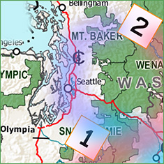 Both my friend’s flights were on time and each piled into my truck and we began to make our way up I-25 toward our first objective, Mt. Baker (Purple route, SeaTac [1] to Baker [2]). Our first lesson was how crowded it is around the Seattle metro area. The I-5 traffic ground to a complete halt for minutes at a time as we battled our way north. We know now that Seattle was on a massive growth-spurt that would last up until current times. But, back in '97 it was quite a surprise. I had hoped we would find a quick pull-off for the night, but it turned out to be quite competitive for any sites. As a result, we had to push farther eastward to find a place unoccupied. We ultimately needed to push into a boondock camp spot between the road and another group's camp for the night. With little privacy in our site, we began to settle into our now somewhat cramped camper volume. The weather was wet with constant gray clouds overhead and light occasional drizzle. The following morning, we promptly escaped the tangle of the metro area to find the Mt. Baker-Snoqualmie National Forest visitor center.
We thought it best to talk with a ranger before committing to a route. He informed us of the year’s massive snowfall and noted that many roads were yet to melt out as a result. We learned that it was customary in the Pacific Northwest (PNW) to let the roads melt-out as the season progressed, evidently it was just too costly to break open the roads each spring. In discussing our climbing objective, the Ranger informed us that our planned approach, Glacier Creek Road, to our Colemen-Demming route was still under snow, adding distance to any ascent. He also mentioned how difficult a rescue could be and encouraged us to be safe.
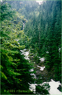 We drove up toward our planned trailhead, pushing as far as we could go with the truck. The tall trees blocked any perspective of the mountain. Worst yet, the clouds hung low, like fog, further obscuring our view. As snow blocked any further progress on the road, our only option would be to start our climb very low elevation wise. We got out of the truck to check things out and we were stunned by what we saw. As we peered into the gray misty cloud cover and trees obscuring the mountain we wondered how exactly how would we proceed? This was our rude introduction to the formidable PNW maritime environment, something I had not considered in my planning. The cold, the wet and the low clouds -- nothing like sunny Colorado at all! In my lack of experience, I had assumed all mountains were like Colorado - oh my!
 I know now that Colorado, by contrast, is a high and dry continental environment and navigation is not a big issue during the spring to summer climbing season. Here in the PNW, not only were the trails obscured by the snow, but there was also low visibility due to the frequent bouts of snow and the low-hanging clouds! As we stood looking at this surprising set of conditions, considering our options, Jack mentioned that his neck was aching. He had been having a moderate issue with his neck in Colorado and had been getting by with some physical therapy there -- but here, in the cold damp weather -- the pain was magnified. Jack proclaimed he might not be cut out for this PNW climbing. I too, had a hard time visualizing how we might bushwhack our way forward from our current spot. All my plans seemed bust.
This all seemed to be a bit much for us. Perhaps we had not slept well the prior night because the situation hit us like a ton of bricks. I know it is hard to believe but GPS was only becoming a new capability at the time. Dean, who was a gadget collector, had recently purchased a hand-held GPS navigator but had never used it before now. Prior to GPS units, a mountaineer would move by compass headings and leave wands - bamboo sticks, usually with attached cloth flags -- to mark the trail for back-tracing the way back out. Although we all had our compasses and a few wands each, we had no experience using them in low visibility situations. For the first time in our lives, we were being challenged to climb a mountain that we could not see. First by finding our way through the towering thick trees and snow and finally through glaciers and mist. Additionally, we had minimal experience with roped travel to protect from the effects of stepping into a crevasse. It all seemed a bit daunting to say the least, and so after a shot discussion of all our lame excuses, we folded. We would move South, first poke around Mount Rainier National Park (MRNP) for a day and then move further down to our next planned ascent, Mount Adams.
MRNP was open, as it usually is year-round, and the three of us became tourists enjoying the visitor center movies and gift shop. The clouds even began to break up, lifting our spirits. We drove the park's plowed roads (federal funding we thought) up to the Paradise Visitor Center. This was a weekday and midafternoon so there were few if any climbers milling about. We stopped by the mountaineer's check-in station, but no ranger was stationed there to chat with us. However, we could see a trail indented into the snow leading upwards as well as some wands marking the way.
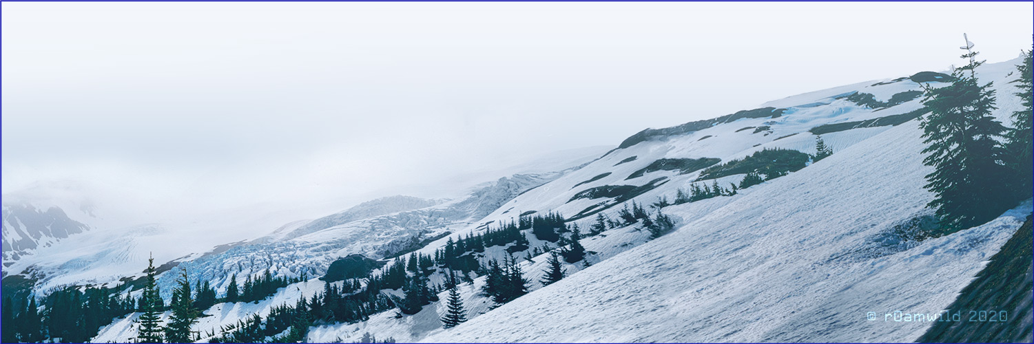
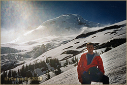 We had time so Dean and I decided to hike up a ways to see if the view would open up, perhaps even to get a better photo of the mountain. The photo taken left, just as we made our way out of the trees, is our high point. We were impressed by Rainier, with its massive glaciers and I vowed that I would return! Mount Rainier aftercall, is Washington State's only fourteen thousand foot peak!